Sunday, August 1, 2010
Colin Could Form Soon
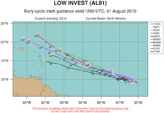
The tropical wave in the central Atlantic looks more disorganized this afternoon than it did at this time yesterday. However, latest data continues to show this system strengthening into a tropical storm within a day. It still too far away to speculate where this storm will eventually make landfall, but it will stay on its WNW course for at least another three to four days.


It's Official
This past July ended up being the hottest ever in recorded history. The average temperature (highs and lows combined) was 82.8, which was very close to the hottest month ever...trailing only August of 1900.
Saturday, July 31, 2010
Cool Lightning Video
I want to share with you this amazing slow motion video of a lightning strike. Enjoy! If you want to learn more about how lightning forms, click on the link below:
http://www.srh.weather.gov/jetstream/lightning/lightning_max.htm
Friday, July 30, 2010
New Record: Most 100 Degree Days in a Year
2010 simply won't quit with the heat records. First we had our hottest Spring on record at Richmond International Airport. Next was the hottest June, and we're almost at the finish line for the hottest July on the books. But Thursday afternoon, our high temperature spiked at 101 degrees (tying the record high for that date) ahead of an approaching cold front that triggered severe storms across the Commonwealth. Thursday, July 29, marked the 10th day this year we've been 100 degrees or hotter. This is the most to ever occur in a single year, surpassing the old record of 9 days from 1954.
Subscribe to:
Comments (Atom)


