Saturday, July 4, 2009

Train Vs. Tornado

This video has been making its rounds on the Internet recently, even though it happened on January 7, 2008. Nonetheless, it is very interesting, check it out!


This tornado moved across parts of northern Illinois and was as strong as an EF-3 at times. Here's the path:

You can find out more at the following link:
http://www.crh.noaa.gov/lot/?n=20080107tor

Showers Headed This Way

Rain has now entered into the Blue Ridge and is headed this way for tonight. It's moving slow enough that you can watch fireworks this evening without worrying about getting wet...which is great news! Showers will enter into the Piedmont around 11 PM and then central VA afterwards.

Friday, July 3, 2009

Independence Day Forecast Update


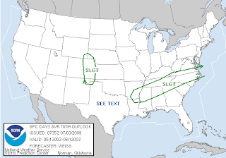
The first half of the holiday weekend should be partly cloudy and pleasant, with temperatures near seasonable averages. Afternoon highs Friday and Saturday will be in the mid- to upper-80's, with morning temperatures in the mid-60's. Saturday evening, there will be a slight chance for a couple of isolated showers and storms popping up, but these should be of the hit-or-miss variety.

By early Sunday, though, our next storm system will be moving into the state, bringing more widespread chances for showers and thunderstorms. A few of those storms may be severe across the southern third of the state, with damaging winds and large hail possible. At this time, it looks like the rain and storms should exit the Commonwealth by late Sunday night.
Have a safe and enjoyable 4th of July!

Thursday, July 2, 2009

Ashland/Doswell Wall Cloud


A supercell thunderstorm moved from extreme western Hanover county through southern Caroline county Wednesday night. A persistent circulation indicated by doppler radar prompted tornado warnings as the storm moved between Ashland and Doswell, very close to Kings Dominion. A CBS 6 viewer known only by "Kevin" snapped the above photo as the storm moved by. The photo was taken facing north, and the storm was moving from left to right (west to east). As you can see from the picture, the wall coud extended very low to the ground, and on Doppler Max 6, there was a well-organized mesocyclone evident. We are fortunate this one didn't produce a tornado.

Gullywashers Wednesday Night

Strong to severe thunderstorms moved through Central Virginia Wednesday night, pounding the Ashland area with penny size hail, downing some tree limbs in other parts of the state, and dumping nearly three-quarters of an inch of rain in half an hour on one of our Weather Watchers in Coatesville. There was a Tornado Warning issued on the storm near Ashland last night, but no touchdown was confirmed.

Here are some of the rain totals from the storms Wednesday:
Coatesville 0.7" in 30 minutes
Reedville 0.6"
Fredericksburg 0.41"
Richmond Intl Airport 0.37"
Newland 0.2"
Locust Grove 0.2"
Farmville 0.16"
Wakefield 0.07"

Wednesday, July 1, 2009

Severe Storms Possible Wednesday


There is the risk for severe storms later this afternoon and evening in Central Virginia as an upper impulse swings through our area around a large, closed low-pressure system to our north in the Great Lakes. Surface dew point temperatures are not that impressive this afternoon, though, only in the 50's and low to mid-60's. Despite limited lower-level moisture, the strong disturbance moving through our area coupled with peak afternoon heating should initiate storms over the higher terrain first, then overspread into Central Virginia through the late afternoon and evening. The primary risk will be for damaging winds, although large hail and isolated tornadoes are also possible.
--Carrie