Saturday, July 10, 2010

Rain Totals - Last 24 Hours

Some areas were lucky and received 1 to 2" of rain, while other areas did not get a drop. Below are maps of estimated rainfall from radar.


Friday, July 9, 2010

A Couple Rain Facts

June 28th was the last time we've seen a good shower in the area (0.43" was officially recorded at the airport). The last time we've seen over a half inch of rain was on May 17th! Tomorrow's rain is definitely much-needed, however, it won't be a drought buster. Be sure to email your rain totals to weather@wtvr.com!

Thursday, July 8, 2010

Tropical Depression #2 Update Thursday


Tropical Depression #2 continues to be very disorganized with maximum sustained winds at just 35 mph. The center, as best the hurricane reconnaissance can determine, is just off the south Texas coast.
It is expected to move inland this afternoon and weaken over the next 24 hours, but drop about 4" to 8" of rain on saturated parts of southern Texas that already received ample rain from Hurricane Alex about a week ago. It does not appear likely that TD #2 will be able to strengthen enough to Tropical Storm strength (must have maximum sustained wind speeds of at least 39 mph with an organized center) and be named Bonnie. Bonnie is yet to be...but there's plenty more of the season to get through:
(Image: Atlantic Tropical Season Activity)

Drought Conditions in Virginia


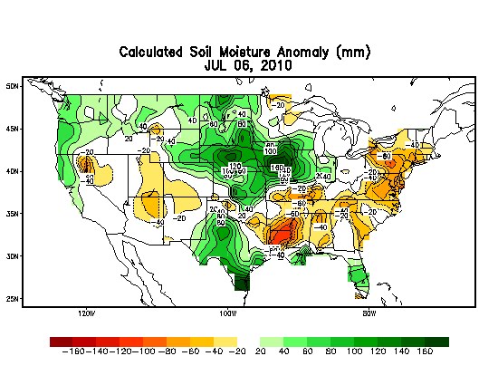
The latest Drought Monitor, just released this morning, confirms what most of us in Virginia already know. We are in the beginnings of a drought. The first level of drought (Moderate) is now affecting about 35% of the state, with nearly everyone else at least abnormally dry. Here is the departure from normal soil moisture for the country, and you can see that we are not the only ones running below average for our precipitation. From the Mid-Atlantic through New England, the same region impacted by the triple-digit heat wave this week, are all badly in need of significant rainfall.
At Richmond International Airport, we are 4.66" below average for our year-to-date precipitation. In the last 40 days, we have received less than an inch of rainfall, none so far in July. March was the last month we were on track for rainfall. We've been below-average for precipitation since April. You can see how our gap has been growing since mid-April:

But we do have a couple things going for us the rest of this Summer in the Mid-Atlantic. For one, we tend to get air-mass thunderstorms often in the summertime. As long as we can stay humid enough, we should get these pop-up showers and storms regularly. Also, we are only in the beginning of our Atlantic tropical season, which will peak September 10 and carry us all the way through November. In Virginia, about 10%-40% of our rainfall in September alone is a result of tropical systems or their remnants. So between summertime storms and an above-average tropical season still expected, we should be able to prevent the drought from becoming a long-term event. In the short-term, though, expect conditions to get worse before they get better.

Wednesday, July 7, 2010

Bonnie Soon to Form?


The second tropical depression of the Atlantic hurricane season developed tonight in the western Gulf of Mexico. Tropical storm warnings have been issued for the Texas and Mexico coasts as conditions appear favorable for strengthening of this system. If a tropical storm forms, it will be named Bonnie.

Triple-Digit Heat Wave About To Break

In the Mid-Atlantic, relief from the triple digit temperatures is on the way in an unusual form. An upper low pressure system has developed over the past couple days in the Atlantic, and it is drifting westward--not your typical northern hemisphere movement of storm systems. Nevertheless, it will drift west as the strong ridge over the East Coast also retreats westward a bit Wednesday.
This low will approach coastal Virginia and North Carolina on Thursday, bringing some cloud-cover and also cooler temperatures aloft that will translate to the surface as well with a northeast to east wind. Moisture content will increase as well, helping highs be held down in the 90's in the Commonwealth while this upper low lingers Friday. By Saturday, a cold front tied to a different low pressure system tracking through Canada will move through the region and bring our best chance for rain and storms late Friday into Saturday, as well as milder air for the weekend with highs in the low-90's. We are running about 4.5" below average for our year-to-date precipitation in Richmond. In the extended forecast, another cold front may bring showers and storms to the region next Tuesday and Wednesday, so we'll be monitoring for that potential and provide updates as we get closer to that next storm system.
Here's a recap of our temperatures at Richmond International Airport this week.
High Temperatures:
Monday, July 5: 100 degrees
Tuesday, July 6: 103 degrees
Record to tie/beat for Wednesday, July 7: 103 degrees (1977). UPDATE: High Wednesday 104 degrees, the hottest temperature in Richmond since August 8, 2007.