Wednesday, September 30, 2009

See the Moon and Jupiter


Skies in central Virginia will clear by mid-evening, allowing everyone to see the moon and the planet Jupiter close together in the sky. The above picture was actually taken yesterday when the two were even closer together. The photograph was taken in Hungary by Monika Landy-Gybnar. Tonight Jupiter will be just below (south) of the moon. You can't miss the pair, they will be the two brightest objects in the night sky.

Coolest Mornings Of Season

The coolest mornings so far this season are expected in Central Virginia Thursday and Friday mornings, when temperatures will likely fall into the 40's. Drier air continues to filter into the Commonwealth Wednesday on the backside of a low-pressure system that is exiting to the northeast. (See map below for Low exiting into Canada northeast of the Great Lakes)

Winds will become light overnight with clear skies, allowing for good radiational cooling conditions. Lower-lying spots may become cooler than other surrounding locations in the morning. The coldest part of the state Thursday morning will be west of I-81 into West Virginia, where Frost Advisories are in effect for overnight into Thursday morning. There, temperatures are expected to dip into the mid-30's for several hours.

Tuesday, September 29, 2009

Tuesday Morning Mountain Waves

West to Northwest winds being lifted over the mountains in West Virginia and western Virginia have helped create a cloud formation known as "Mountain Waves" or "Lee Waves," because these are clouds that form in the lee of the mountains. When the air is orographically lifted on the "windward" side of the mountain, the air condenses and forms a cloud. On the other side of the mountain, the air begins to descend, and the sky is clear there. But an oscillation has begun in the atmosphere, so the air rises again, condenses, and forms another row of clouds on the leeward side of the mountain.
This oscillation can continue for miles, and we are seeing that early this morning in the Commonwealth! Watch the visible satellite loop here.

Monday Rainfall & Severe Reports

The strong cold front that moved through the Commonwealth Monday afternoon and evening did kick off some strong to severe thunderstorms in the region with locally heavy rainfall. Here is a snapshot of the storm-total precipitation:
(Radar image from Wakefield at NWS)
The highest rain totals were in northern Sussex County, with up to 4"-5" in isolated spots. More widespread totals were in the 2"-3" range in the swath of yellow.
Here are the severe weather reports from Monday:
Severe weather reports included Quarter to Golf-ball Size Hail in Boydton in Mecklenburg County, and also tree damage in South Boston, Ringgold, and Nathalie in south-central Virginia.

Monday, September 28, 2009

Blustery Monday

A low-pressure system tracking through the Great Lakes today and into New England will bring blustery winds to the Commonwealth from the Southwest at 15-25mph. Here is a snapshot of the surface at 2PM this afternoon:
The red shade is the warm air ahead of the cold front, associated with the surface low pressure in the Great Lakes. The pressure gradient associated with this low is pretty tight, which will lead to the sometimes blustery winds in Central Virginia today at 15-25mph. The strongest winds, though, will be closer to the Low, where Wind Advisories are in effect today across the Upper Midwest and Great Lakes. Winds in the warned regions will be 25-45mph, with some higher gusts possible.
In addition to the wind, there will be a slight chance for a few late afternoon and evening showers and storms east of I-95 and into Southeast Virginia. Because of all the wind shear, though, and the drier air rapidly moving into the state, storm chances are low.
As this system tracked through the Northern Plains Sunday, here are some of the max wind gusts reported:
North Dakota:
Dickinson 59 MPH
Hettinger 58MPH
Killdeer 56MPH
St Anthony 54MPH
Garrison 53MPH
Jamestown 53MPH
Williston 51MPH
Minot 51MPH
Watford city 50MPH
Bismarck 8N 50MPH
Minot AFB 49MPH
Bismarck Airport 48MPH
South Dakota:
Chamberlain 55 MPH
Huron 53 MPH
Madison 53 MPH
Yankton 48 MPH
Sioux Falls 47 MPH
Brookings 46 MPH
Mitchell 46 MPH
Minnesota:
Windom 45 MPH
Slayton 45 MPH
Marshall 44 MPH
Worthington 43 MPH
Pipestone 43 MPH
Jackson 39 MPH
Luverne 39 MPH
Iowa:
Spencer 46 MPH
Storm Lake 45 MPH
Le Mars 44 MPH
Orange City 44 MPH
Sheldon 43 MPH
Cherokee 40 MPH

Sunday, September 27, 2009

Summer Recap

Although we are almost a week into fall, I want to briefly look back at this summer.

TEMPERATURES
First of all, temperatures were warmer than normal for most of the state. The same could be said for most of the Deep South and West Coast. However, it was an extremely cool summer for folks in the Midwest, especially in Nebraska, Iowa, Minnesota and the Dakotas.


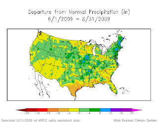
RAINFALL
Although some parts of the Commonwealth experienced wetter than normal conditions, most of central Virginia was below normal for rainfall. It was also dry in South Carolina, Georgia and especially Texas. Most of New England and parts of the Midwest experienced a wet summer.