Sunday, July 18, 2010

Heat Wave - Crunching The Numbers

So far this year we have seen 33 days in the 90s and 6 days in the 100s. We experienced the hottest June on record and more than likely this will end up being the hottest July on record. When you combine highs and lows, the average temperature so far this summer (meteorological summer is June, July, August) is 81.26. The hottest summer on record was in 1900, where the average temperature was 79.6. So if this pattern persists, then this will end up being the hottest summer on record! No wonder why my energy bill is so high...

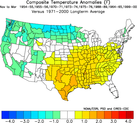
We are still tracking a developing La Nina off the western coast of South America.


Temperatures typically stay above average during late fall and winter during La Nina years, so it's plausible that this warm weather pattern will continue into next year!

Saturday, July 17, 2010

Weather Update - 5:00 PM Saturday

The severe threat has now diminished. A few showers and isolated thunderstorms will persist into early this evening, especially in the southeastern third of the state. Skies will then become partly cloudy later tonight and into tomorrow morning. I'll post the rain totals later tonight.

Weather Update - 12:45 PM Saturday

A line of strong thunderstorms has developed along the Blue Ridge Parkway. These storms are moving east at 25 mph. The air is very unstable ahead of this line, so I'm expecting these to strengthen. A Severe Thunderstorm Watch will probably be issued shortly.

Friday, July 16, 2010

Weather Update - Friday 5:30 PM

Widely scattered thunderstorms continue to develop across the area. The strongest storms will be capable of very heavy rain, frequent lightning, hail and some wind damage (there have been reports of tree damage in southwest and south central Virginia). The activity will slowly diminish once the sun goes down. We are covering storms live on our website at www.wtvr.com/weather. We should see another round of isolated storms on Saturday and Sunday.

Thursday, July 15, 2010

July Heating Up

We're now half way through the month of July, and our average temperature is running about 3 degrees above normal. That's pretty warm, but not even in the top 10 in hottest Julys on record for Richmond. It looks like that might be about to change. There has been a consistent signal in the extended model solutions over the past several days that a large ridge of high pressure will be building into the region next week. This pattern will result in our third wave of triple-digit heat bracketed by several days of highs in the upper 90s. Should this materialize, we could easily follow up the hottest June on record with the hottest July on record. I've already included triple-digit heat in our 7-day forecast, and will have updates over the next several days.

Drought Update July 15: Eastern Shore Included in Moderate Drought


Despite the scattered afternoon and nighttime thunderstorms we had earlier this week that produced localized totals from a half inch to around two inches, drought conditions did not change in the main body of Virginia and continued to expand since last week's Drought Update onto the Eastern Shore. Now about 37% of Virginia is in D1, the first level of drought. While these quick rain events do help with river and stream levels, as Zach mentioned in our previous blog, they aren't significant and lasting enough to raise the soil moisture content out of the drought and abnormally dry conditions prevalent across nearly the entire state.